In today’s connected world, knowing our location is essential. The Global Positioning System, or GPS, is a revolutionary technology. It changed how we navigate and interact with our surroundings.
Initially, GPS was designed for military use. Now, it serves many civilian purposes. We use it for driving directions, fleet management, and environmental tracking.
This article looks at the history of GPS. It also explores its technological advancements. Furthermore, we discuss the prospects of GPS. This system helps us find our way daily. Additionally, it supports broader scientific exploration.
Join us as we examine GPS’s role in navigation. Discover its profound impact on our modern lives.
What is GPS (Global Positioning System)?
GPS is a global navigation satellite system. It helps determine the position of objects, people, vehicles, or ships.
This accuracy extends to within centimeters. The U.S. Department of Defense developed and operates GPS. With this system, navigating the world becomes easy and reliable.
In 1952, the Soviet Union launched the Sputnik I satellite. Scientists monitored it by observing the Doppler effect of its signal.
This led to studies on using satellites for location tracking. By examining the Doppler frequency, they could determine an observer’s position.
The U.S. Navy adopted this technology for navigation. They used it to provide accurate location data to their fleet. In 1964, the TRANSIT system became operational.
Commercial use began in 1967, but updates were infrequent. Observers needed to stay nearly stationary for reliable information.
Later in the decade, atomic clocks advanced satellite systems. Each satellite carried a synchronized clock, improving timing accuracy.
In 1973, the Navy and Air Force developed a new encryption technique. They used a signal modulated with a PRN code, calling it NAVSTAR GPS.
From 1978 to 1985, eleven NAVSTAR prototype satellites were launched. This effort completed the satellite constellation.
In December 1993, they declared “First Operational Ability.” By April 1995, they achieved “Full Operational Ability.”
On May 2, 2000, President Bill Clinton enabled A-GPS for civil use. In 2009, he signed a deal with the ICAO.
This agreement allowed GPS for air navigation. Meanwhile, Cuba, with Chinese Technologies, integrated GPS into their systems.
Their main goals included improving control and optimizing resources. This integration aimed to enhance mobile phone benefits, like fuel savings.
Development of the GPS System
GPS is evolving into a more robust system. This improvement increases usability and reduces complexity.
The GPS III program aims to meet both military and civilian needs. It was developed with a flexible approach, allowing for future adjustments and risk reduction.
Additionally, new positioning systems were created. The IPS-2, or Inertial Positioning System, captures data efficiently. It allows users to measure in real-time while on the go. This feature is known as Mobile Mapping.
The system uses 3D mobile mapping, relying on a laser scanner, inertial sensor, GNSS system, and a vehicle odometer.
Thanks to these three positioning technologies—IMU, GNSS, and the odometer—users can measure accurately. This ensures great precision, even in areas where satellite signals are weak.
Earth in Space
Our closest star, the Sun, is one of billions in the Milky Way. Earth is one of the nine planets orbiting the Sun.
The planets nearest to the Sun are Mercury, Venus, Earth, and Mars. Beyond them are Jupiter, Saturn, Uranus, Neptune, and Pluto.
Scientists study the movement of these planets in Celestial Mechanics. Notable figures like Johannes Kepler and Isaac Newton made key discoveries in this field.
Gravity is the force that holds the planets together. It also determines their movements.
The closer a planet is to the Sun, the stronger the gravity. This results in faster orbiting speeds.
For instance, Earth is about 150 million km from the Sun. It travels at an average speed of 30 kilometers per second. Consequently, Earth completes its orbit around the Sun in one year.
Satellites Orbiting the Earth
Scientists have designed artificial satellites for Earth and Mars. These satellites help us understand celestial mechanics and study moon motion.
Powerful rockets launch satellites into space. If the launch speed is too low, gravity pulls the satellite back. If the speed is too high, Earth’s gravity can’t keep it in orbit.
Today, many satellites orbit Earth for various purposes. They are used for telecommunications, weather, military applications, and scientific research. Some satellites have orbits synchronized with Earth’s rotation.
Satellites are called geostationary when their speed matches Earth’s rotation. These satellites remain in the same spot in the sky. Communication is essential for sending and receiving signals to and from satellites.
Radio waves are the primary means of communication. They help broadcast television and radio programs.
Positioning
Determining a position on Earth involves finding latitude and longitude coordinates.
Most receivers display these values in degrees (°) and minutes (‘). These coordinates represent both latitude and longitude angles.
Therefore, measurements are based on a precise 0° reference point. Understanding this is crucial for accurate location finding.
Latitude: Northern and Southern Hemispheres
Latitude measures location based on Ecuador, which is at 0° latitude. A point can be in the northern or southern hemisphere.
If it’s in the northern hemisphere, it will have an N. Conversely, if it’s in the southern hemisphere, it will have an S. Additionally, northern latitudes use positive numbers.
Meanwhile, southern latitudes are represented by negative numbers. Understanding these basics helps with accurate navigation.
Length: East, West
Longitude is measured from the Greenwich Meridian. You can measure angles east or west of this meridian.
When you do this, use the letter E for east and W for west. Each number indicates the specific longitude. This system helps standardize navigation and mapping.
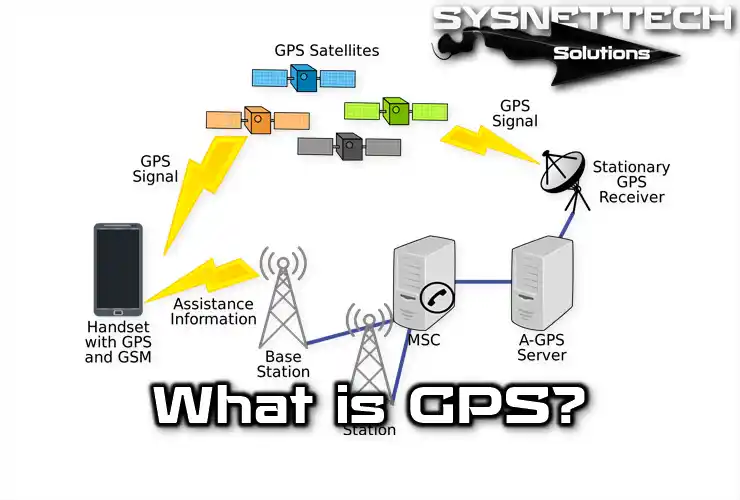
Global Positioning System
GPS, or Global Positioning System, consists of 24 satellites. These satellites are spread across six orbits. Each orbit has four satellites.
This setup ensures that at least eight satellites are visible from almost anywhere on Earth.
The GPS satellites orbit about 20,000 km above the Earth. They complete two full orbits each day.
Each satellite sends signals containing location information and the time of emission.
GPS receivers can decode signals from multiple satellites. They combine the information to determine locations on Earth. This gives latitude and longitude coordinates.
Typically, the accuracy is around 10 meters. However, high-quality receivers can achieve precision within a few millimeters.
GPS Receiver
GPS receivers provide accurate time and location information from satellites. They use two types of data: almanac data and precise timing data.
Almanac data includes general details about each satellite’s location and operation. Receivers can obtain this information from any satellite.
Once a GPS receiver has the latest almanac and time data, it searches for satellites.
When it detects signals from at least three satellites, it calculates their positions on Earth. This process yields longitude, latitude, and altitude information.
Typically, GPS receivers connect to more than three satellites. The more signals they receive, the more accurate the position calculation becomes.
Initially designed for military use, GPS technology is now widely available for civilian purposes.
However, GPS accuracy can vary. The average error in position calculation is about 15 meters.
If higher precision is needed—such as for research, mapping, or races—many companies offer optional antennas. These antennas help correct errors for specific receivers, enhancing accuracy significantly.
Usage Areas of the GPS Receiver
You can use a GPS receiver for various projects. These devices calculate your exact location.
However, they do not work with analog data. GPS receivers are great for navigation tasks, route tracking, and storing points. Keep in mind, you cannot extract atmospheric data from them.
Many personal GPS models have been reliable in aviation and marine navigation for years. They offer essential benefits for personal navigation on land.
First, in motor vehicles, these devices help guide you effectively. Additionally, aviation and marine navigation systems are larger and more accurate.
As a result, the receivers designed for these systems often offer advanced features. Overall, GPS receivers provide more tools than you may need for basic navigation.
Working Logic of the GPS Receiver
Satellites help determine their locations by sending information to receivers.
This information, called an Almanac, is updated every 5-20 minutes. The receiver stores these almanacs for the entire satellite constellation.
Each satellite also sends detailed data called an ephemeris. This includes satellite health, position in space, atomic time, and Doppler information.
The GPS receiver uses this data to sync its clock with the atomic clocks on the satellites.
This synchronization happens every second on portable receivers. Once synced, the receiver can measure distances to the satellites.
Each satellite indicates a point on a sphere focused on itself, transmitting the distance to the receiver.
When the receiver gets data from two satellites, it finds a perimeter where their spheres intersect.
Adding a third satellite narrows down the possible locations to two points. One point is often disregarded due to its implausibility.
However, since the receiver’s clock isn’t synced with the satellites, both points remain uncertain.
A fourth satellite’s information resolves this syncing issue. Now, the intersection of the four spheres shows a precise location, despite some uncertainty from clock differences.
DGPS (Differential GPS)
DGPS, or Differential GPS, improves GPS accuracy by correcting satellite data.
This system enhances the calculated location for users. When GPS faults occur, they can affect nearby receivers. DGPS transmits error corrections directly to these receivers.
This helps correct system errors within the coverage area of reference GPS equipment. Additionally, we need to model the mistakes in both space and time.
Expanding DGPS coverage is crucial, as is reducing the number of fixed reference receivers. These steps will ensure better accuracy for all users.
Advantages of Routing Systems
Satellites in orbit send vital yet straightforward data. This data offers reliable information for today’s sensitive technology.
People use satellites to predict atmospheric changes and environmental conditions. This helps in planning various activities effectively.
Additionally, GPS devices have powerful navigation functions. They can redefine how we understand directions. For instance, you can create routes on a map easily.
You can also save essential points on the device. When you enable a route, it shows if you are on track.
Furthermore, this technology can measure your exact speed. It helps maintain a straight direction while moving.
Overall, satellites and GPS enhance our navigation and environmental understanding significantly.
Using Received Data on a Computer
To transfer data from a GPS receiver to a computer, you need special tools. These tools help send data between devices.
Typically, you will also need specific software to import this data. The most common interfaces are NMEA 0180, 0181, and 0183. This software can transfer data through the serial port easily.
Moreover, RS232 interfaces can facilitate transfers from parallel ports. Additionally, many GPS manufacturers have their own interfaces. These firm-specific structures help with data transfer, too.
Conclusion
In conclusion, the Global Positioning System has changed how we interact with the world. It started as a military tool.
Now, GPS is crucial for everyday navigation. This technology is a foundation of modern life.
Furthermore, GPS is constantly evolving. It promises better accuracy and efficiency in navigation. Also, it has many uses in scientific research and resource management.
As we look ahead, new technologies will likely improve GPS even more. This will make it an even more essential tool for us.
By using GPS, we can navigate our physical surroundings and the complexities of our connected world.

TolgaBagci
Hi, I'm Tolga, a computer expert with 20 years of experience. I help fix computer issues with things like hardware, systems, networks, virtualization, servers, and operating systems. Check out my website for helpful info, and feel free to ask me anything. Keep yourself in the loop about the newest technologies!